The Lessons in XKCD’s Transit Map of North America
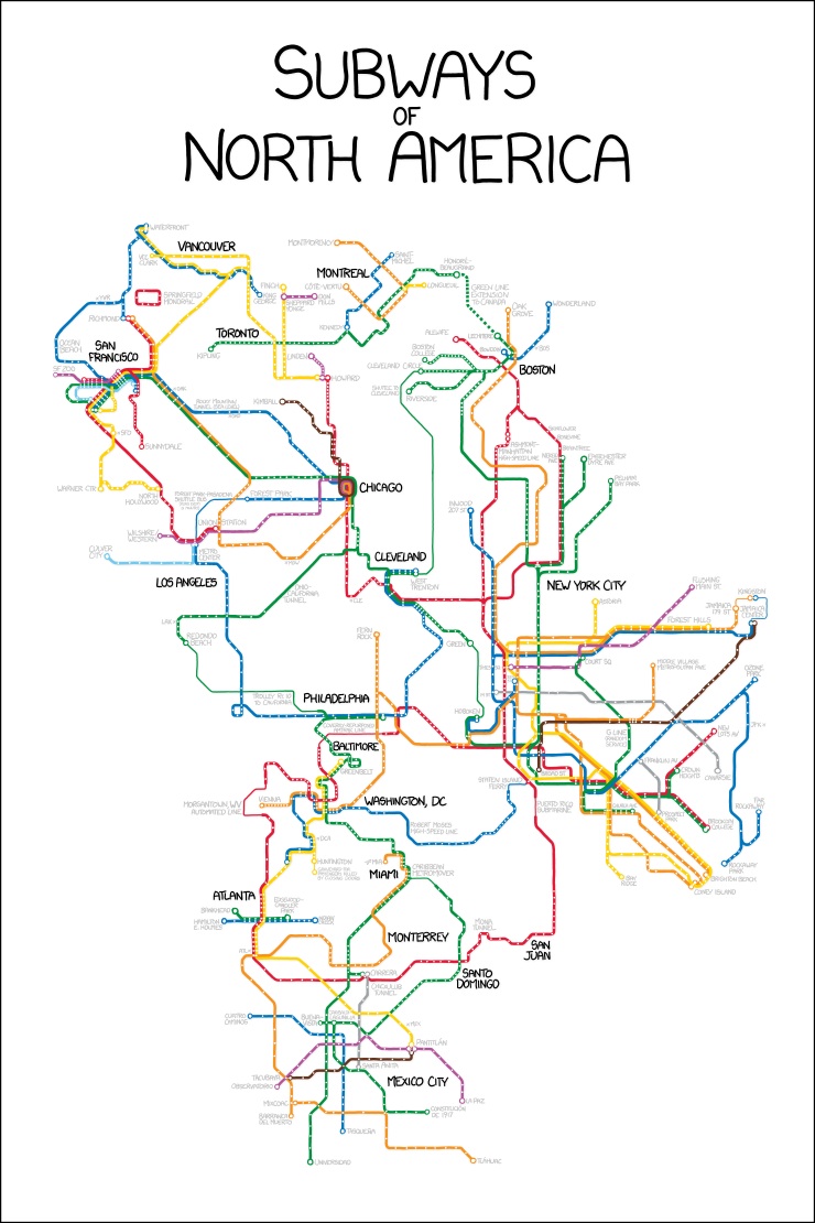
Massachusetts’s own Randall Munroe, the mind behind the brainy web comic XKCD, has put most of North America’s metro systems on the same map, connecting them with some fictional subway lines of his own. Like many an epic XKCD before it, the comic creates a sprawling world and allows the reader to explore within it. (Look out for the monorail of Simpsons fame.) It makes for a fun game of “what if,” but more than that, there are some solid takeaways to be gleaned about our subway systems. For example:
1. The Green Line extension is officially just a source for bitter humor. If you live in Boston and you read about the constant budget woes of those who would expand the Green Line into Somerville, then you’ll enjoy the fact that Munroe chose Boston’s Green Line as his connection to the Canadian rail systems on the map. He amusingly names it “The Green Line Extension to Canada” because, haha, we’re totally put together enough to make that happen, right?
2. New York’s subway system dwarfs the rest. Okay, so you probably aren’t learning this for the first time, but the sad truism gets a particularly stark visual portrayal here. As the Transit Maps Tumblr notes:
What the map does show well, even in its cartoon-like execution, is the complete dominance of New York’s subway system (the mouseover tooltip for the comic states that about one in three North American subway stops are in NYC). Randall has remained quite faithful to the actual official system maps for each component city, so New York ends up taking up a huge portion of the map.
In related news …
3. Subway maps aren’t remotely drawn to scale. It’s always helpful to keep in mind when judging distances between stops that you’re better off inputing your trip into Google Maps than eyeballing the best route based on the subway drawing. The MBTA map, and transit maps in general, can be misleading. Park Street and Downtown Crossing might look like they’re as far away as Charles/MGH and Kendall Square. But they’re just suffering from “enlarged center syndrome.” That is, they’re drawn that far apart because the density of stations at the center of Boston requires that the stations be spread out further than a to-scale drawing would allow. The same considerations show why Munroe had to make it appear as if New York City takes up the majority of the continent. (New Yorkers’ opinions of their own place in the world aside, this is a distortion.) He had a lot of subway stations to fit into it.
And with that, we leave you to explore Munroe’s creation and yearn for a world where sunny California is just $2 and a few thousand Red Line stops away. (Also, click over to XKCD to see it large.)