Finally, Snow! Forecasters Say a Whole Lot of It Is Coming Saturday
As much as a foot could fall in Boston this weekend.

via National Weather Service
Update: Find the latest on the storm slated to hit Boston Saturday night here.
After a long wait, Boston is expected to finally see some serious snow—as much as a foot of it!—this weekend, forecasters say.
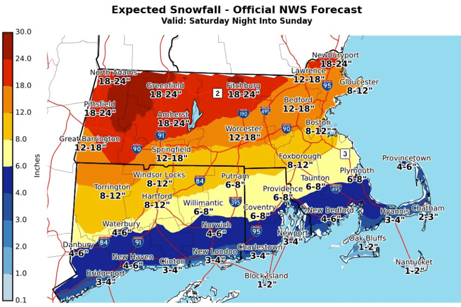
The National Weather Service is forecasting anywhere between 8-12 inches of snow Saturday night into Sunday morning, as a powerful winter storm is expected to slam into the region.
Winter Storm Watch for most of SNE, may be expanded farther south later today. Hazardous travel due to heavy snow & icing Sat night-Sun. Here are the latest snow & ice forecasts. Note these totals will likely need adjustments later today! pic.twitter.com/zxUtbbNcKc
— NWS Boston (@NWSBoston) January 17, 2019
An uncertain blend of snow and rain is expected, NWS says, which could cut into the total accumulation as the flakes may transition to a wintry mix overnight, and potentially turn to rain. You know what that means: NWS is warning everyone to make plans ahead of the weather, and if conditions get rough to stay off the roads if travel becomes dangerous.
As an appetizer, Boston is also expecting some light snow (maybe less than an inch) Thursday night into Friday morning, which could impact the commute.
Looking further into the rest of the winter, there has also been some talk about the “polar vortex” bringing some potentially very chilly and snowy conditions to the region for what could be weeks.
So if you’ve been craving piles of snow and dying to take those sleds out of storage, the time has come. And maybe, be careful what you wish for.
Weekend Storm Timing: Here’s a rough idea of what to expect. Snow arrives Sat night, transitions to a wintry mix Sun morning, and probably to all rain near Cape/Islands. Mix/rain should make it a little farther north after 7 AM Sun but uncertainty is very high! Stay tuned. pic.twitter.com/KlRdwcjOtE
— NWS Boston (@NWSBoston) January 17, 2019


