Early Spring Hikes to Enjoy across New England
It may still be chilly, but it's a good time to hit the trails.

Photo of Giant Falls by Miles Howard
New England’s prettiest waterfalls are thawing—and you should go chase them! To the north and west of Boston, what we call “spring” is better known as “mud season.” Massive snow plumes are melting. The long-frozen soil is softening again. Venturing into the forest at this time of year pretty much guarantees that you’ll get dirty. So naturally, most people stay home and save their hiking trips for summer or fall. But ironically, hikers who sit out mud season are missing one of the most awe-inspiring naturalistic events of New England―the thawing of our waterfalls!
Snowmelt transforms waterfalls into rip-roaring monsters of liquid and woodsy detritus at this time of year. It’s not uncommon to see small trees being whisked away like feathers in the torrent of spring waterfalls. This sight, paired with the eerie calm of the under-visited woods, makes for a sublime experience that you’ll be hankering for in July when trails are often more popular. But don’t worry: You won’t be completely alone. Mud season is also the time when baby animals and birds start emerging from the woodwork, often serenading hikers brave enough to visit waterfalls in spring.
So what are you waiting for? Grab a walking stick (helpful for crossing streams,) some waterproof hiking boots (ditto,) and a pair of microspikes (crucial for negotiating any leftover snow or ice), and hit the trails to these enchanting New England waterfalls, as our natural world comes to life again.
Note: If you have any symptoms associated with the coronavirus, please stay home to avoid the possibility of contagion and overwhelming rural medical systems. And if you do go, continue to practice good social distancing on the trails: Keep your distance from other hikers, bring your own food, and wash your hands thoroughly pre- and post-hike.
NEW HAMPSHIRE
PURGATORY FALLS
Location: Mont Vernon, NH
Distance: 60 miles from Boston, 1.5 hour drive
Length of hike: 5.1 mile out-and-back hike
Difficulty: Easy
Best time to visit: Early May
For more information: mountvernonnh.us
Tucked away in Merrimack River Valley woods, here are two powerful cascades that bookend a gentle hike along Purgatory Brook. While there are multiple access points to the trail, the best approach is to park your car at the Lower Purgatory Falls trailhead on Purgatory Road. Follow rectangular yellow blazes into the forest for five minutes and you’ll arrive at the glittering pool of Lower Purgatory Falls, which crashes down a series of sloped rock faces and is routinely painted and photographed by visiting artists. To reach the Upper Falls, continue north along the brook as the trail climbs into the foothills and arrives at an overlook ledge for the second cascade, which plunges 25 feet from a rocky sluice.
ARETHUSA FALLS
Location: Crawford Notch State Park, NH
Distance: 166 miles from Boston, 3 hour drive
Length of hike: 2.8 miles out-and-back trail
Difficulty: Easy to Moderate
Best time to visit: Late May
For more information: nhstateparks.org
Allegedly the tallest waterfall in New Hampshire (more on the “allegedly” at our next destination,) the 140 foot-high plunge of Arethusa Falls is a sight that humbles thousands of visitors each year. But few people take the time to check out the warmup cascades that flank the trail to the falls. Start your hike by crossing the railroad tracks in the Arethusa Falls trailhead parking lot and picking up the blue blazed falls trail. Shortly after, veer left onto the yellow blazed Bemis Brook Trail as it descends briefly to the titular brook and visits Coliseum Falls (named for its coliseum-like rocks) and then, Bemis Falls (a trilogy of horsetail cascades.) After a brief uphill scramble, you’ll re-join the trail to Arethusa Falls. Turn left and continue to the epic cascade.
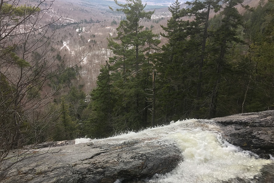
Photo of Dryad Falls by Miles Howard
GIANT FALLS…and DRYAD FALLS
Location: Shelburne, NH
Distance: 182 miles from Boston, 3 hour drive
Length of hike: 3 miles out-and-back hike
Difficulty: Moderate
Best time to visit: Mid-May
For more information: alltrails.com
The northeastern edge of the Whites is a place where most hikers never venture, and that’s their loss, because Giant Falls—an 80 foot-tall behemoth of water—rumbles here in solitude. Not only that, but a few miles north of Giant Falls, an even bigger 300 foot-tall cascade called Dryad Falls makes brief seasonal appearances in springtime and fall. (In summer, it dries up and resembles a damp cliff.) The trailhead for Giant Falls is easy to miss, but it’s right next to 267 North Road in Shelburne. Look for the Peabody Brook Trail sign, park your car on the shoulder of the road, and follow a grassy trail with blue blazes as it climbs steadily into a birch forest and reaches a rocky terrace from which you can admire Giant Falls. It’s another two miles (with notable elevation gain) to reach the Dryad Falls Trail, which delivers you to a sheer ledge beside the state’s true tallest waterfall.
MAINE
ANGEL FALLS
Location: Township D, Maine
Distance: 204 miles from Boston, 3.5 hour drive
Length of hike: 1.4 miles out-and-back trail
Difficulty: Moderate
Best time to visit: Late May
For more information: alltrails.com
Inland Maine has more undeveloped forest than any other state in the continental U.S., and when you hike to Angel Falls, you feel that immense wilderness. It’s actually a relatively short hike to reach the towering 90 foot-tall plunging cascade, which many consider to be the most stunning waterfall in Maine. But first, you’ll need to drive up Bemis Road, leaving civilization behind, until you reach a Y-junction with a crude sign for the falls nailed to a tree. Turn left here, park your car just a few yards down the road, and follow the red blazes into the forest along a path that crosses several streams. (Depending on the water level, you may need to take your boots off while fording the streams!) After negotiating some slippery rocks, the trail ascends a height of land to arrive at the misting majesty of Angel Falls.
JEWELL FALLS
Location: Portland, Maine
Distance: 110 miles from Boston, two hour drive
Length of hike: Variable length out-and-back or loop trails (plan for 1-2 miles)
Difficulty: Easy
Best time to visit: Early May
For more information: trails.org
It’s easy for a modest 22 foot-tall cascade like Jewell Falls to be overshadowed by heavyweight northern siblings, but this little gem—the only natural waterfall in Portland—holds the distinction of being the only cascade on this list that you can reach without a car. The waterfall is located on the north side of Fore River Sanctuary, which is only 10-20 minutes west of the Portland transit center by foot or city bus. It’s a spiderweb of unblazed and interlinked trails through wildflowery woods, over bog bridges, and along a briney canal. We recommend bringing a map and taking your sweet time as you amble toward Jewell Falls. (Be sure to snap a picture from the beautiful wooden bridge near the top of the cascade.)
VERMONT
LYE BROOK FALLS
Location: Manchester, VT
Distance: 152 miles from Boston, 3 hour drive
Length of hike: 4.6 miles out-and-back hike
Difficulty: Moderate
Best time to visit: Mid-May
For more information: usda.gov
Next time you feel like the tuft-like green hills, red barns, and speckled cows of Southern Vermont are almost insufferably wholesome, enter the Green Mountain National Forest and hike up to Lye Brook Falls for a more primordial example of beauty. At 160 feet tall, this spattering cascade is reached by a series of old logging roads. This is the Lye Brook Trail. Follow the blue blazes as the trail goes from gravel path to a slabby ledge that traverses a hillside, and keep your ears open for the chuckling of water ahead. The falls can be seen from a cliff that marks the trail’s end, and it affords a killer view of the step-like rock formation that the massive cascade tumbles down.
MOSS GLEN FALLS
Location: Stowe, VT
Distance: 202 miles from Boston, 3.5 hour drive
Length of hike: 0.5 miles out-and-back trail,
Difficulty: Easy
Best time to visit: Mid-May
For more information: alltrails.com
On the edge of Vermont’s Northeast Kingdom, near a busy road heading into Stowe, one of the most majestic waterfalls in Vermont lies waiting for those willing to leave the asphalt behind. At 125 feet tall, the plunges and horsetail formations of Moss Glen Falls can feel like something out of a Tolkien anthology. But you won’t have to slog through hundreds of pages or miles of forest to reach this cascade. It’s a gentle quarter mile stroll that begins with little wooden bridges through a shrubby bog before transitioning into hemlock woods and reaching Moss Glen Brook (note the crashing of water nearby.) A brief rooty climb up a steep hillside delivers you to a overlook ledge where you can gaze into the ravine through which Moss Glen Falls spills. While the trail does go further up along the falls, the initial view can’t be surpassed.